Alexander County
Land Development Plan
November 1993
This report was financed in part by a grant from the
Appalachian Regional Commission, administered through the
North Carolina
Department of Commerce,
Division of Community Assistance.
* These sections were added to the original report for the purposes of the Alexander County Hazard Mitigation Plan and were not included in the original presentation to the Alexander County Board of Commissioners in 1993. Where possible, practical or relevant general plans, policies and practices were included in this section or the "data developed" section of this plan.
|
Alexander County Board of Commissioners |
Land Development Plan Steering Committee | ||||||||||
|
Phil Icard, Chair |
Hans AuBuchon | ||||||||||
| Johnny Campbell | Kathy Bunton | ||||||||||
| Tim Glass | James Fortner | ||||||||||
| Fred Lackey | Nancy Kerley | ||||||||||
| Craig Mayberry | Connie Killian | ||||||||||
| Charles R. "Dickie" Liddle | |||||||||||
| Alexander County Staff | John Watts | ||||||||||
| Charles Mashburn, County Administrator | |||||||||||
| Greg Atchley, County Planner | Prepared by: | ||||||||||
| The Western Piedmont Council of Governments | |||||||||||
| John T. Kenny, Ph.D | |||||||||||
| Michael Legg | |||||||||||
| Phillip Lookadoo | |||||||||||
|
Table of Contents |
|||||||||||
| INTRODUCTION | |||||||||||
| Project Overview | |||||||||||
| Alexander Land Development Plan: The Process | |||||||||||
| Citizen Questionnaire | |||||||||||
|
Purpose and Goals |
|||||||||||
| CHAPTER 1: ALEXANDER COUNTY PROFILE | |||||||||||
| Population | |||||||||||
| Housing | |||||||||||
| Employment | |||||||||||
| Income and Spending | |||||||||||
|
Education |
|||||||||||
| CHAPTER 2: CURRENT LAND USE | |||||||||||
| Residential | |||||||||||
| Industrial | |||||||||||
| Commercial | |||||||||||
| Institutional | |||||||||||
| Agricultural/Open Space | |||||||||||
|
Current Policies and Regulations Affecting Land Use |
|||||||||||
| CHAPTER 3: ENVIRONMENTAL CONDITIONS | |||||||||||
| Soils | |||||||||||
| Topography | |||||||||||
| Hydrography and Wetlands | |||||||||||
| Floodplains | |||||||||||
| Watersheds | |||||||||||
| Protected Plants and Animals Species | |||||||||||
|
Designated Game Lands |
|||||||||||
| CHAPTER 4: COMMUNITY FACILITIES | |||||||||||
| Cultural and Historic Resources | |||||||||||
| Recreation | |||||||||||
| Fire Protection | |||||||||||
| Police Protection | |||||||||||
| Schools | |||||||||||
|
Medical Services |
|||||||||||
| CHAPTER 5: INFRASTRUCTURE | |||||||||||
| Roads and Highways | |||||||||||
| Water | |||||||||||
| Sewer | |||||||||||
| Other Utilities | |||||||||||
|
CHAPTER 6: FUTURE LAND USE |
|||||||||||
|
CHAPTER 7: ISSUES, GOALS
AND STRATEGIES |
|||||||||||
| TABLES | |||||||||||
| Table 1 Population Growth, 1980-1990 | |||||||||||
| Table 2 NC Population Growth Projections | |||||||||||
| Table 3 Township Population, 1970-1990 | |||||||||||
| Table 4 Net Migration and Natural Increase, 1980-1990 | |||||||||||
| Table 5 Households, 1980-1990 | |||||||||||
| Table 6 Housing Data | |||||||||||
| Table 7 Manufactured Home Data | |||||||||||
| Table 8 Real Property Tax Base, 1980-1990 | |||||||||||
| Table 9 Labor Force Profile | |||||||||||
| Table 10 Alexander County Business Employment | |||||||||||
| Table 11 Household Income, 1980-1990 | |||||||||||
| Table 12 Per Capita Income, 1980-1990 | |||||||||||
| Table 13 Gross Retail Sales, 1980-1990 | |||||||||||
| Table 14 Population 25+ with 8 Years Education, 1980-1990 | |||||||||||
| Table 15 Percent High School Graduates 25 and Older | |||||||||||
| Table 16 Alexander County Soils Data | |||||||||||
| Table 17 Summary of Proposed Water Supply Watershed Rules Applicable to New Development in Alexander County | |||||||||||
| Table 18 Endangered, Threatened and Rare Species | |||||||||||
| Table 19 Alexander County Parks and Facilities | |||||||||||
|
FIGURES |
|||||||||||
| Figure 1 Percent Population Growth, 1960-1990 | |||||||||||
| Figure 2 Alexander Township Population, Percent Change, 1970-1990 | |||||||||||
| Figure 3A Alexander County Age Distribution, 1980 | |||||||||||
| Figure 3B Alexander County Age Distribution, 1990 | |||||||||||
| Figure 4A Percent Families in Poverty, 1980-1990 | |||||||||||
| Figure 4B Female-Headed Households in Poverty 1980-1990 | |||||||||||
| Figure 5 Dropout Rates, Grades 7-12, 1991-1992 | |||||||||||
| MAPS | |||||||||||
| Map 1 Alexander & Comparison Counties | |||||||||||
| Map 2A In Commuting | |||||||||||
| Map 2B Out Commuting | |||||||||||
| Map 3 Current Land Use | |||||||||||
| Map 4 Soils Inventory (available in paper form only at this time) | |||||||||||
| Map 5 Development Constraints (available in paper form only at this time) | |||||||||||
| Map 6 Water Supply Watersheds | |||||||||||
| Map 7 Community Facilities (available in paper form only at this time) | |||||||||||
| Map 8 Roads and Highways | |||||||||||
| Map 9 Utilities Service Areas (available in paper form only at this time) | |||||||||||
|
Map
10 Future Land Use (available in paper form only at
this time) |
|||||||||||
| Project Overview | |||||||||||
|
The Appalachian Regional Commission (ARC) has provided funding to allow the
29 ARC mountain area counties of North Carolina to develop a land use
planning program under a uniform set of guidelines. The Mountain Area
Planning Program (MAPP) is being coordinated by the North Carolina
Department of Commerce, Division of Community Assistance. The general purpose of the MAPP is to develop a set of policies and strategies by local governments aimed at guiding public and private decisions regarding land use and development. Emphasis is placed on identifying strengths and weaknesses appropriate to each county. The program also encourages preserving natural and economic resources. |
|||||||||||
| Alexander Land Development Plan: The Process | |||||||||||
|
A grant application for the project was submitted by the Alexander County Board of Commissioners in August 1992 and was approved by the North Carolina Department of Commerce in October 1992. The Western Piedmont Council of Governments agreed to work with the Alexander County Planning Department to implement the project. Data for the plan was gathered from a wide variety of sources, including federal, state and local agencies such as the US Census Bureau, the NC Employment Security Commission, the Soil Conservation Service, the NC Wildlife Resources Commission and the NC Natural Heritage Program. Additionally, Appalachian State University’s Department of Geography and Planning and the NC Department of Commerce, Division of Community Assistance, played key roles in the mapping portion of the Plan. In March 1993, seven Alexander County residents were appointed by the Board of Commissioners to serve as members of a Steering Committee to assist in developing the Plan. The Steering Committee was created to (1) help identify the County’s strengths and weaknesses, (2) participate in three public forums, (3) review the project planners’ data and analysis, (4) assist the project planners in developing goals, objectives and strategies and (5) review the draft Land Use Plan. Seven meetings of the Steering Committee were held to
discuss both existing conditions, current trends and future strategies.
Three public forums, held in different areas of the County, sought to
promote awareness of the need for land use planning to improve both the
natural and economic quality of life. The forums were also intended to be
used as a method of obtaining insight from County residents concerning
strengths and weaknesses. |
|||||||||||
| Citizen Questionnaire | |||||||||||
|
To solicit additional citizen input, a short questionnaire was distributed to residents throughout the County (primarily at Convenience Centers). The response to the questionnaires was moderate with 117 adequately completed questionnaires being returned. It should be noted that the distribution, collection and analysis of the responses was not intended to be a scientific process. The limited circulation precluded any attempt at obtaining scientifically accurate results. The sole purpose of this exercise was to obtain general input from residents concerning major issues affecting the growth and development of the County. The results should not be construed in any other way. The questionnaires were divided into three sections. The first section asked residents to rank 11 pre-determined issues from 1 (most important) to 11 (least important). Secondly, the residents were asked to provide comments concerning their perceived strengths and weaknesses in Alexander County. The last section attempted to gather demographic information (age, occupation, residency) from the residents completing the questionnaires. The respondents were mostly male (55%) with 22% female and 23% giving no response. Thirty-nine percent of the 117 respondents were between the ages of 30 and 49, 21% were between 50 and 69, 10% were over age 70, 5% were under 30 and 24% did not respond to this question. Slightly more than 41% of those answering live in the County's more urban areas (Bethlehem and Taylorsville), 9% live in Wittenburg and 26% scattered throughout the County's rural communities. Almost 25% did not list their home community. The majority of the respondents (35%) indicated that they work in Alexander County. Seventeen percent listed retired or unemployed to this question. Nearly 13% answered that they worked in Catawba County. Nearly 8% worked in other counties or multiple counties. The final 22% did not respond to this question. The 11 pre-determined issues are listed on the following
page. The average response, the percent of respondents ranking the issue in
the top three as well as the bottom three are indicated. Overall, the
highest ranking issue based on the average response was "better schools"
(3.80) followed by "better jobs" (4.38). The least important issues based on
the average response were "keeping the County’s rural heritage" (7.71) and
"more parks and recreation" (7.53). Surprisingly, "protecting the
environment" ranked third, ahead of water, sewer and road improvement needs. |
|||||||||||
| 1. | Better schools: | 3.80 | 7. | Developing industry/industrial parks: | 5.99 | ||||||
| 2. | Better jobs: | 4.38 | 8. | Land use management : | 6.58 | ||||||
| 3. | Protecting the environment: | 5.18 | 9. | Lower housing costs: | 7.37 | ||||||
| 4. | Water service: | 5.18 | 10. | More parks and recreation: | 7.53 | ||||||
| 5. | Sewer service: | 5.38 | 11. | Keeping the County’s rural heritage: | 7.71 | ||||||
| 6. | Road and traffic improvements: | 5.62 | |||||||||
Similar to the average responses, 60% of the respondents placed "better schools" as one of the top three issues facing Alexander County. Likewise, more than 46% placed "better jobs" in the top three. Less than 13% felt that "land use management" or "more parks and recreation" were one of three most important issues. Each of these issues and the percent of respondents who felt the issue was one of the three most important are listed below. |
|||||||||||
| 1. | Better schools: | 60.1% | 7. | Road and traffic improvements: | 23.9% | ||||||
| 2. | Better jobs: | 46.2% | 8. | Keeping the County’s rural heritage: | 18.8% | ||||||
| 3. | Water service: | 38.5% | 9. | Lower housing costs: | 17.9% | ||||||
| 4. | Sewer service: | 37.6% | 10. | Land use management : | 12.8% | ||||||
| 5. | Protecting the environment | 31.6% | 11. | More Parks and Recreation | 12.0% | ||||||
| 6. | Developing industry/industrial parks: | 28.4% | |||||||||
|
Conversely, almost 56% of those surveyed felt that "keeping the County’s rural heritage" was one of the least important issues. Fifty-one percent ranked "more parks and recreation" as one of the three least important issues. |
|||||||||||
| 1. | Keeping the County’s rural heritage: | 55.6% | 7. | Developing industry/industrial parks: | 28.4% | ||||||
| 2. | More parks and recreation: | 51.3% | 8. | Protecting the environment: | 14.5% | ||||||
| 3. | Lower housing costs: | 46.2% | 9. | Road and traffic improvements: | 11.1% | ||||||
| 4. | Land use management: | 24.8% | 10. | Better jobs: | 9.4% | ||||||
| 5. | Water service: | 21.4% | 11. | Better schools | 8.5% | ||||||
| 6. | Sewer service: | 21.4% | |||||||||
|
A significant number of additional comments concerning the County's strengths and weaknesses was gathered from the questionnaires. The vast majority of the strengths listed centered around the people that live in Alexander County and its rural environment. These comments included the strong work ethic, the natural beauty, "a good place to live and raise a family," " community closeness," "peaceful life-style," "lack of trouble." Others individuals cited the availability of land and its potential for development as a prominent strength. |
|||||||||||
|
The weaknesses mentioned by citizens were almost exclusively centered around
three issues: (1) the lack of water and sewer services, (2) the lack of jobs
and new industries and (3) the lack of recreational opportunities,
especially for young people. The County school system was also mentioned as
a weakness.
|
|||||||||||
| Purpose and Goals | |||||||||||
| Alexander County has recognized the need for land use planning as one method to guide and manage future growth. The Land Development Plan investigated several options to accomplish planned growth. Generally, the purpose of the Land Development Plan is to: | |||||||||||
|
|||||||||||
|
|||||||||||
|
Specifically, the following issues have been
identified as a basis for developing detailed goals, objectives and
strategies: |
|||||||||||
| Issue I |
Protection of the County’s drinking water. |
||||||||||
| Issue II |
Expansion of public water and sewer services. |
||||||||||
| Issue III |
Management of the County’s transportation facilities. |
||||||||||
| Issue IV |
Promotion of economic growth and development. |
||||||||||
| Issue V |
Guidance of future growth and development in areas with prime development
potential through land use management
techniques. |
||||||||||
| Issue VI |
Preservation of natural, historic and cultural resources. |
||||||||||
| Issue VII |
Provisions for safe, affordable housing. |
||||||||||
|
The data collected and analyzed in the Plan provides a detailed information base to assist policy makers in making informed decisions concerning future growth and land development in Alexander County. The analysis of the existing conditions, the foundation
upon which the Plan was built, is contained in the first five
chapters: "Alexander County Profile," "Current Land Use," "Environmental
Conditions," "Community Facilities" and "Infrastructure." |
|||||||||||
| Chapter 1: |
"Alexander County Profile" includes a wide range of population and
demographic information aimed at providing a statistical basis for the
Plan. |
||||||||||
| Chapter 2: |
"Current Land Use" provides an explanation of existing County land use
patterns and classifies the uses into seven major categories. The Current
Land Use Map delineates these categories. |
||||||||||
| Chapter 3: |
"Environmental Conditions," is a series of maps depicting soil types and
development constraints (excessive slopes, floodplains, game lands and water
supply watersheds). This information and what it means to the future land
development of Alexander County is analyzed in this Chapter. |
||||||||||
| Chapter 4: |
"Community Facilities," provides a brief look at existing parks, schools,
medical, fire and police facilities. This inventory pinpoints existing
deficiencies and will help determine future needs based on population trends
and projections. These facilities are important facets in the County’s
quality of life. |
||||||||||
| Chapter 5: |
"Infrastructure" is perhaps the most important inventory. Most development
follows new or improved roads and expanded utilities. Thus, knowing where
roads, water lines or sewer facilities exist is vital to implement
successful future land development strategies. This Chapter provides an
inventory of these facilities. |
||||||||||
|
The
information included in Chapters 1 - 5 was used to (1) pinpoint the County’s
strengths and weaknesses; (2) develop future land use scenarios, presented
on the Future Land Use Map, found in Chapter 6; and (3) formulate the future
development issues, goals and strategies which are outlined in Chapter 7. |
|||||||||||
| CHAPTER 1: ALEXANDER COUNTY PROFILE | |||||||||||
|
Population and demographic characteristics of Alexander County are included in this section. This valuable information provides a composite of Alexander County’s past and present as well as current trends. From this information a foundation for future land development decisions can be based. The profile is intended to provide insight into the
makeup of the County, its people and significant changes over time. It is
also intended to provide a comparison between Alexander and other western
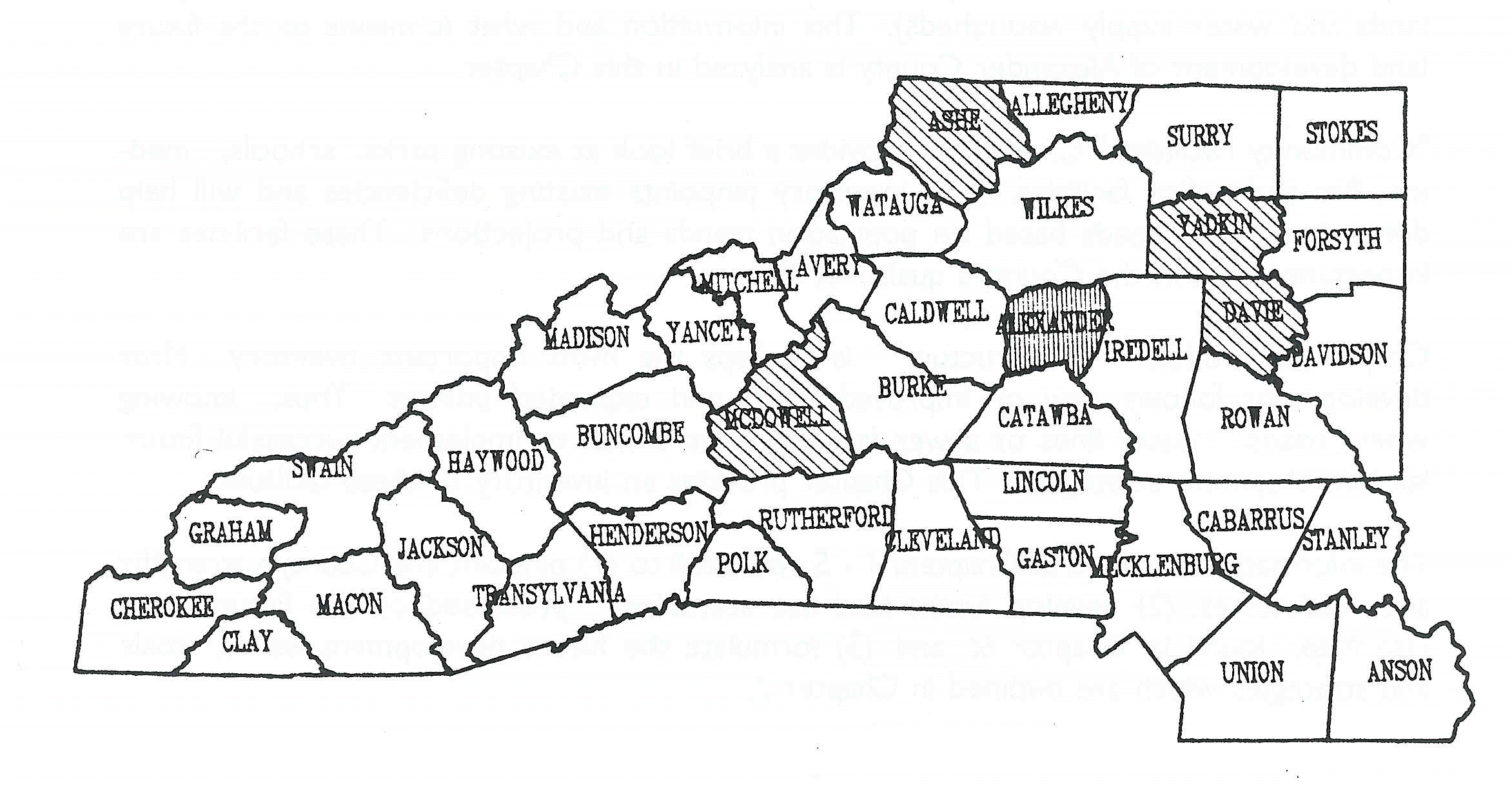
North Carolina counties of similar population. Four counties have been
selected for the analysis: Ashe, Davie, McDowell and Yadkin (see
Map 1). |
|||||||||||
|
Map 1 |
|||||||||||
|
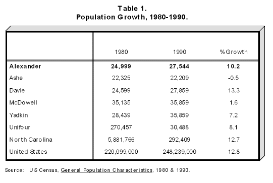
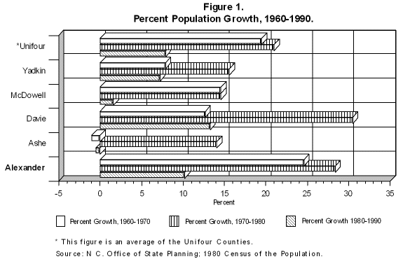
Nearby counties such as Wilkes and Iredell are not included in the analysis because of notable differences in population. For the same reason, the individual Unifour counties were also excluded. Due to Alexander’s proximity to Catawba, Burke and Caldwell Counties, as well as the traditional placement of Alexander within the four county region, the Unifour as a whole was often included. Demographic characteristics analyzed in this section include population, housing, employment, income/spending and education. Total Population and Population Growth Table 1 displays total population data for Alexander County, several comparable counties, the Unifour, North Carolina and the United States. Alexander County’s 1990 population of 27,544 was second lowest among the comparison counties. Alexander’s population grew 10.2% in the 1980-1990 decade, second to Davie County. Growth for Alexander was higher than the Unifour as a whole although approximately 2% lower than both the state and national averages. Figure 1 shows that in the two decades previous to 1980-1990, Alexander County grew 26.4% from 1960-1970, highest among the comparison counties, and in the 1970-1980 decade at 28.4%, second to Davie County.
|
|||||||||||
|
|
|||||||||||
|
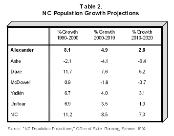
Future population for all counties in the comparison counties, the Unifour and NC, as presented in Table 2, follows a general trend of decreasing growth from 1990-2020 and, in some cases, even a negative growth. Alexander County is projected to move from 10.2% growth in 1990 to 2.8% growth in 2020. Despite this decreasing growth trend, Alexander County is expected to exceed the Unifour average by a large margin as well as remain second in growth among the comparison counties. This projected growth is an encouraging sign for the economic health of Alexander County. This projected growth rate, however, is expected to remain below population growth in North Carolina.
|
|||||||||||
|
Growth in township population within Alexander County from 1970 through 1990, as depicted in Table 3, shows which townships are contributing most to the County’s growth. Most of the growth for the County has occurred in Wittenburg Township, which grew 105.1% from 1970-1990 and 19.4% from 1980-1990. Growth in the Bethlehem area accounts for most of this population increase. One issue of concern may be that many of these Alexander residents work, shop and dine in Hickory rather than in Alexander County. Wittenburg, though currently behind Taylorsville Township in total population, is fast approaching Taylorsville Township’s population and may soon surpass it.
|
|||||||||||
|
It also shows that during the past ten years Millers and Little River Townships are growing at about the same rate as Wittenburg Township, suggesting that the County’s growth is being distributed more evenly than in earlier years. Figure 2 also illustrates that Taylorsville Township had the lowest percent growth from 1980-1990 (1.6%) in the County. |
|||||||||||
|
|
|||||||||||
|
A great deal of useful information can be derived from an age distribution chart (Figures 3A and 3B). Age distribution charts describe specific age ranges such as 0-5 year olds or persons over age 65. Alexander County lost population in the 0-4 years age range which is consistent with the slower growth in population for the 1980-1990 decade. The 3.2% decrease in this population group shows a low birth rate for the County, in contrast a with 3.3% growth rate in the same population group for the Unifour area. One result of a low birth rate is a difficulty in replacing the workforce. The age group which includes people ages 15-24 represents future population growth. In Alexander County, this group has dropped at a rate of 6.7% which supports population projections for future decades. This fact suggests a drop in the workforce for the immediate future. The four age groups from ages 15-64 represent the bulk of the workforce. Examining this combined population reveals that it grew by 2,515 or 20.4% in the 1980-1990 decade. One age group that distinguishes itself from the others is the 65 and over range which grew 34.7%, almost 9% more than the others. Growth in this age group suggests that proper measures should be taken to ensure that adequate facilities for medical and health care are provided to accommodate persons in this age range. |
|||||||||||
|
|
|||||||||||
|
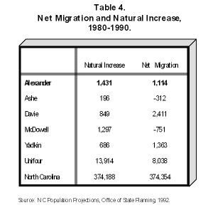
Out-migration, low in-migration (number of people moving into an area from elsewhere) and a low natural increase are seen playing major roles in this decreasing population growth across the Unifour, the state and the nation. Natural increase, as it applies to population, is defined as births minus deaths for a specific time period. From 1980 to 1990, Alexander County’s natural increase was 1,431 which represents 10.3% of the Unifour's natural increase. Alexander’s natural increase was higher than any of the comparison counties as is shown in Table 4. A net migration figure for an area is found by subtracting the number of people who left the area from the number of people who moved into the area. Table 4 shows that Alexander County had a net migration of 1,114 or 4.5%, considerably higher than the Unifour’s average of 2.9%. Although this percentage is encouraging, the actual number of new Alexander residents is small compared, for example, to other Unifour counties.
|
|||||||||||
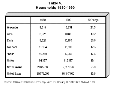
| The term "household" may be unclear and needs to be defined. A household includes a family, two or more people living together who are related by birth, marriage or adoption. Households also include one person living alone or two or more persons living together who are not related, such as roommates. | |||||||||||
|
|
|||||||||||
|
The number of households in Alexander County has risen at a rate of 21.3% from 1980-1990. Alexander’s rate of household growth is well above the Unifour and national averages and is only slightly lower than the state average of 23.0%. Once again, this rate of household formation represents an encouraging sign for the County. Alexander County ranks second to Davie County (with 26.6% growth) among
the comparison counties. |
|||||||||||
|
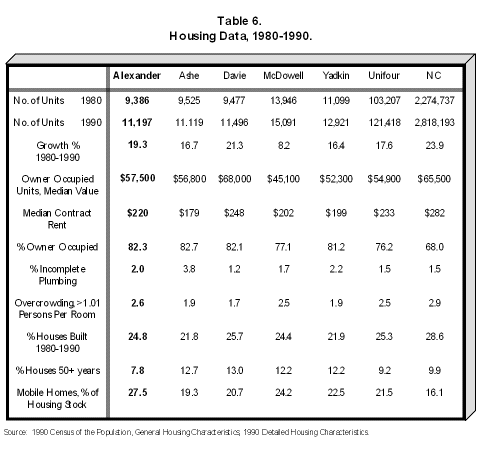
The number of housing units in Alexander County increased by 19.3% from 1980-1990 for a gain of 1,181 housing units. The increase in the number of households required new residences, thus the increase in total housing units. This number, of course, makes no mention of the kind or quality of the available housing units. The median housing value in 1990 was $57,500. Median contract rent for 1990 was $220 per month. Median housing values and median contract rent for Alexander County rank third in the comparison counties. Table 6 shows 2.0% of the housing stock is without complete plumbing facilities, the highest percentage of its kind in the Unifour. This figure raises some concerns about the quality of the available housing stock. The percent of the Alexander County housing stock built between 1980 and 1990 totaled 24.8%. Table 6 also shows that Alexander County has the lowest percent of houses over 50 years old in the comparison counties (7.8%) and is lower than the Unifour average. This means that the majority of the housing stock has adequate structural strength and will not need to be rebuilt in the near future.
|
|||||||||||
|
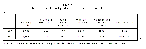
Mobile homes, or
manufactured homes as the industry terms them, account for 27.5% of the
housing stock in the County. Affordability of mobile homes and costs of site
constructed homes are contributing factors to the increasing number of
mobile homes from 1980-1990. Alexander County reflects a trend occurring throughout the Unifour and the state, although the percent of manufactured homes is higher than in the comparable counties, the Unifour or the state. The number of manufactured housing units in Alexander County increased 97.9% from 1980-1990. It also increased 10.7% of total housing units from 16.2% in 1980 to 26.9% in 1990. (See Table 7.)
|
|||||||||||
|
The tremendous amount of manufactured housing growth can be recognized when it is compared to the growth of stick-built homes which grew only 4.1% from 1980-1990. One reason for the large increase in manufactured housing is
affordability. The price of stick-built homes is expensive and will continue
to increase in the future. Manufactured housing offers people a way to own
their own home at a lower price, especially younger couples buying their
first home. |
|||||||||||
|
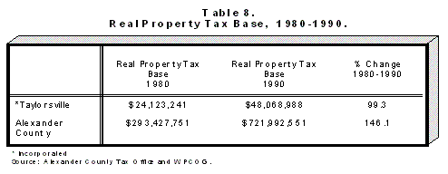
Table 8 illustrates Alexander County’s real property tax base, the municipal share of the County, and the portion which is unincorporated.
|
|||||||||||
|
EMPLOYMENT
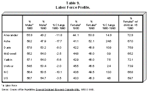
Table 9 displays labor force information for the 1980-1990 time period. One of the significant trends that can be seen is the change in the male to female ratio from 1980 to 1990. This change is evident in Alexander County, the five comparison counties, the state and the nation some of the geographical areas, Alexander County included, women have become the majority of the workforce. An important fact to note is that most of these working women (nearly 73% of them in Alexander County) have children under the age of six. This situation is true of the Unifour and North Carolina but less so of the nation as a whole. This important change has widespread implications for issues of child care, women’s health and workplace safety.
Areas where this reversal has not occurred experienced a similar
situation in which the ratio of women to men workers moved towards
equivalency. Alexander County, where the male percent of the workforce
decreased by 11.8%, followed the state rather than the national pattern. |
|||||||||||
|
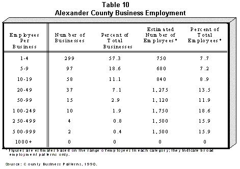
As one can see by looking at Table 10, industry in Alexander County is dominated by small business. For our purposes small businesses include employers with fewer than 20 employees.
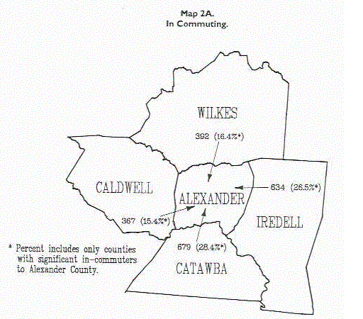
This data displayed in Table 10 also tells us that a few large businesses supply most of the employment opportunities for the County. The percent of small businesses in the County totals 87%. The number of businesses with 500-999 employees doubled since 1985, and the percent of the total for that group grew by 5.0%. This expansion was attributed to expansions by two furniture industries. An examination of commuting patterns for Alexander County residents reveals the County has 6,742 persons — almost 43% of its labor force — commuting to other counties for employment. This data may imply serious concerns about the availability of jobs within Alexander County. Map 2A shows information on persons who live in other counties and travel to Alexander County for employment. The county from which Alexander receives most of its commuting employees is Catawba County, supplying 679 persons or 28.4% of the total number of in-commuters. Second is Iredell County with 634 persons or 26.5%. Three other counties have enough employees commuting to Alexander County to be worth noting: Wilkes County (16.4%), Caldwell County (15.4%) and Davidson County (5.0%).
|
|||||||||||
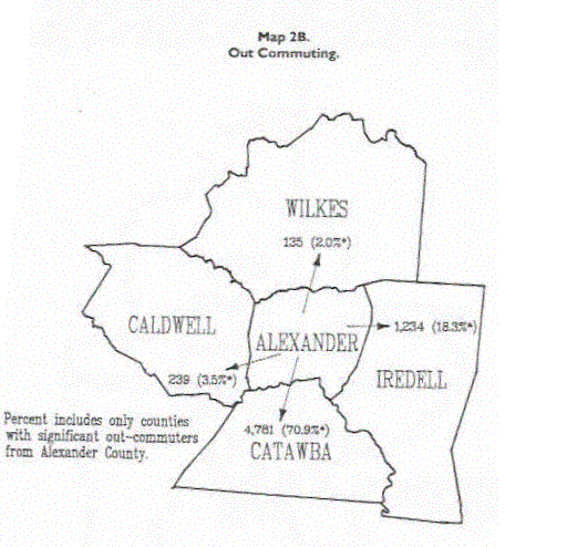
| Map 2B depicts which
counties are receiving Alexander workers and the number of Alexander
residents commuting to each county. The county employing the most Alexander
residents is Catawba County. Catawba County receives 70.9% of all
out-commuters from Alexander County. Iredell County is the second largest
with 18.3%. Numbers three and four, Caldwell and Wilkes Counties, receive
3.5% and 2.0% in that order.
|
|||||||||||
|
The ratio of Alexander out-commuters to in-commuters is large. One reason for such a high out-commuter rate is that many people living in the Bethlehem area are employed in Catawba County. More importantly, more and higher paying job opportunities exist in Catawba County than in many Alexander County industries. The new US 64 - NC 90 Highway, when completed, may
attract new industry to provide jobs for eastern Alexander County residents
and persons from other counties seeking employment. This road may
dramatically affect the current commuting trends. |
|||||||||||
|
INCOME and SPENDING |
|||||||||||
|
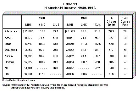
Table 11 displays information pertaining to median household income for 1980 and 1990. Data show the percent of NC and US incomes held by each of the comparison counties and the Unifour.
In the ten year period, the median household income increased
dramatically, 76.9% and 82.5%, respectively. The figure is not outstanding
among the comparison counties, but both gains exceed the national percent by
a large margin. Drastic increases in incomes during the 1980-1990 period are
partly due to inflation but largely the result of increase in women workers
which formed two-income households. On the other hand, one might argue that
lower paying industries have practically required two workers in each
household so they can survive economically. |
|||||||||||
|
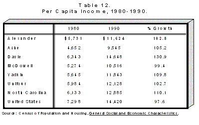
Per capita income is a term that is derived by compiling the total income of an area and then dividing that number by the total population of that area. Per capita income basically represents an even distribution of wealth across the population. As shown in Table 12, Alexander County has increased its per capita income by 102.8%, one tenth above the Unifour average and 5.2% above the national average. Despite its large percent growth, Alexander’s actual per capita income, $11,624, ranks third in the comparison counties behind Davie and Yadkin Counties.
|
|||||||||||
|
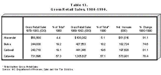
Table 13 illustrates that Alexander County had the lowest gross retail sales (GRS) during the ten year period of all five counties and was lower than the Unifour average. Alexander County’s growth in GRS was 91.1%, higher than the Unifour average and all counties in the comparison counties except for Davie County’s GRS which increased by 140.6%. Table 13 shows that, even though Alexander’s GRS is sizably smaller than the Unifour average, it is still holding its own and gaining ever so slightly in percentage. Catawba County, and especially the Hickory area, remain one of the state’s highest areas of gross retail sales.
|
|||||||||||
|
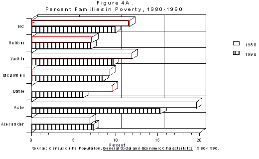
Alexander County in 1980 had the lowest percentage of families in poverty of all the comparison counties and was also lower than the Unifour average. Figure 4A illustrates that in 1990 all counties, except for Alexander County, lowered their percentage of poverty-stricken families. Alexander County from 1980-1990 saw a rise in the percentage of families in poverty from 6.9% to 7.3%, and fell second to Davie County in lowest percent of poverty-stricken families. This increase from 1980 to 1990, though slight, presents a concern that needs careful monitoring by social service agencies.
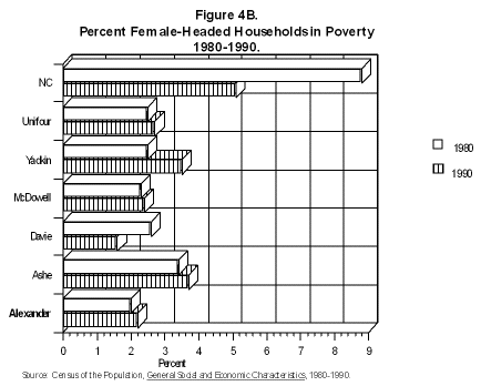
Figure 4B displays the percent of female-headed households in poverty for 1980 and 1990. In this category in 1980, Alexander County had the lowest percent in the comparison counties. By 1990, however, Alexander County saw an increase in the number of female-headed households in poverty. The County, however, remains well below the state and Unifour averages and below all comparison counties but Davie for female-headed families in poverty.
|
|||||||||||
|
EDUCATION |
|||||||||||
|
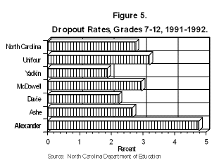
Dropout Rates Information in Figure 5 shows dropout rates for the study counties. For the 1991-1992 school year, Alexander County’s dropout rate was 4.78% which was higher than the Unifour average and higher than all of the five counties in the comparison counties. The high percentage of high school dropouts must remain a concern for educators and employers alike.
|
|||||||||||
|
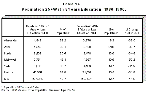
Table 14 displays the population age 25 and over, as well as the number and percent of those who have only up to eight years of education for Alexander, the comparison counties, the Unifour and the state. Alexander County in 1980 had 4,846 persons or 33.2% of those 25 and over who possessed only eight years of education. In 1990 that figure dropped dramatically to barely 18%. This change represents substantial success.
The 25 and over age population in Alexander grew by 22.4% while the percent with eight years education fell by 32.5% points. This means more people are getting a better education and that more people are staying in school longer. It also means that the percent of the population who only have up to eight years of education are growing older and dying off. The actual figures, as shown in Table 14, tell us that in 1990 total persons 25 and over with eight years education were 3,270 or 18.3% of the 25 and over population. Among the comparison counties, Alexander County was doing better than all but one county in increasing the education level of its residents, a fact worthy of special emphasis. As compared to the state, however, Alexander County had 5.6% more people
with only eight years of education. Alexander County dropped 17.6%, more
than double, in this category from 1980-1990. Progress is being made in
Alexander at a rate faster than in the state, although a higher percent of
Alexander residents have only an eighth grade education than across the
state. |
|||||||||||
|
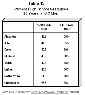
Table 15 contains information regarding the percent of those persons 25+ who have graduated from high school. In 1980 43.9% of the 25+ population in Alexander County graduated from high school; by 1990 that number dramatically increased to 59.0%. Alexander County ranked second highest of the counties studied in the actual percent of high school graduates age 25+ in 1990. In the same fashion, Alexander County increased its percent of persons with a high school diploma by a much greater percent than did the state or the nation, but in 1990 still lagged behind the state and the nation in its percent of high school graduates 25 years and older.
|
|||||||||||
|
Schools in North Carolina are funded by three distinct
sources: the state, which provides the majority of the funding for current
expenses; the federal government, which funds specific programs for distinct
populations; and local funds, which are mainly levied by the local County
Commissioners based on the property tax. Money for capital expenses is
provided by local governments with additional funds provided through the
state sales tax. Some localities also provide for a special supplementary
tax for education; no Unifour local government, however, levies such taxes.
|
|||||||||||
|
CHAPTER 2: CURRENT
LAND USE |
|||||||||||
|
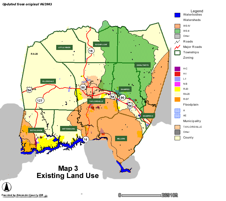
An existing land use
inventory is perhaps the information most often used in making sound
decisions regarding future land use and land development. The Current Land
Use Map (see Map 3) represents general land use patterns in Alexander
County. The map delineates the major land use categories including
Residential, Commercial, Industrial, Institutional and Agriculture/Open
Space.
The predominant residential use is detached single family dwellings on individual lots. However, manufactured homes on individual lots and manufactured home parks represent a significant portion (27% in 1990) of the County’s housing stock. Duplexes and apartment buildings are a minor portion of the residential inventory. A detailed analysis of the County’s housing stock and current trends can be found in Chapter 1: County Profile. For the County as a whole, the residential densities are extremely low (less than 1.5 dwelling units per acre). However, there are higher densities in the Bethlehem, Stony Point and Hiddenite areas as well as in and around Taylorsville. As indicated by Map 3, the majority of residential development has occurred along existing State-maintained roads and highways. With the exception of a few subdivisions in the Bethlehem, Hiddenite and Stony Point communities, most residential development is linear in nature. This is due in part to the lack of extensive water services and essentially little sewer service available beyond the Town of Taylorsville. Large scale residential development is often not practical without these services. The linear development pattern can also be attributed to historic development patterns common in rural counties. These patterns exist when large scale land is often transferred among family members and never offered for anything more than minor development purposes. The market for residential development appears to be increasing in the Bethlehem community as indicated by the population growth in the Wittenburg Township (see Chapter 1: County Profile). This trend is also supported by building permit data for the southwestern portion of the County. Residential building permit data from the Hickory-Newton-Conover Metropolitan Planning Organization (MPO) indicates that from 1984-1992, 301 residential building permits were issued for the southwestern sections of the County (south of the Bethlehem Elementary School). The residential growth for this area was 36%, considerably higher than the 29% residential growth rate for the entire Hickory-Newton Conover MPO.
|
|||||||||||
|
The primary industrial development patterns in Alexander County consist of development along the major highways. As with residential development, most industrial development is scattered throughout the County. There are discernable clusters of industrial establishments in the Bethlehem, Stony Point and Hiddenite areas and in and around Taylorsville. There is also a distinct pattern of industrial development along much of NC Highway 16, especially south of Taylorsville. Sufficient land suitable for industrial development exists along each of
the existing highways as well as along the new Highway 64-90 corridor.
However, as with residential development, the lack of sewer service
essentially prevents large scale industrial development of any kind. It also
prevents the establishment of industrial parks or clustered industrial
development. |
|||||||||||
|
Commercial Similar to the pattern of residential and industrial development, most existing commercial development is found along existing roads, often in "strip" style shopping areas. In Alexander County, determining the difference between commercial and industrial establishments is highly subjective. Much of the commercial development (for example, warehousing, repair garages) found in rural, industrial-based counties such as Alexander would be considered light industrial in more urban counties. This type of development is scattered throughout the County, again, mostly along major State-maintained highways. Most of the traditional traffic oriented, service-sector commercial development exists in and around the Town of Taylorsville and along Highway 127 in the Bethlehem community. These appear to be the healthiest of the County’s commercial areas. There is also some smaller scale commercial development in the Stony Point and Hiddenite areas. However, it is clear that certain commercial areas, especially in Stony Point, are suffering from relatively wide-spread vacancies and business failures. Many of the community’s storefronts are empty and parking lots remain deserted.
|
|||||||||||
|
Institutional
This land use category consist of schools, parks and other public lands.
These uses are extremely limited and are generally located around
residential areas. The complete inventory of these facilities is outlined in
Chapter 4: Community Facilities. |
|||||||||||
|
Agricultural /
Open Space More than three-fourths of the County’s land is either vacant, open space, farmland or forested land, categorized here as Agricultural/Open Space. The majority of this undisturbed land is found in the northern half of the County where the road network is not as advanced, floodplain land abundant and topographic slopes greater. Portions of this land are considered prime farmland due to the existence of appropriate agriculture soils. Many of these areas are located around identified floodplains. Other portions closer to the major highways are more suited for commercial and industrial development. Over time, small scale, low-density residential development will continue to fill the vacant land throughout the County.
|
|||||||||||
|
Current Policies
and Regulations Affecting Land Use Increasingly, residents in some areas of Alexander County are becoming more concerned with the manner in which the County is growing and developing. The Town of Taylorsville has been enforcing a Zoning Ordinance and Subdivision Regulations since the 1960s. In 1987 the County adopted a Zoning Ordinance for the Bethlehem community in efforts to promote some orderly development patterns in the face of rapid growth. There are, however, no adopted Subdivision Regulations in Bethlehem, nor are there on-going land use planning programs. No other portions of Alexander are presently under the control of growth management or land use regulations. The Alexander County Health Department enforces a free-standing manufactured home park ordinance, designed to protect the health of residents living in manufactured home parks. This ordinance requires a minimum of 1/2 acre spaces for all new parks. Existing manufactured home parks are exempt from the regulations but all expansions must comply. The ordinance defines a manufactured home park as a single tract of land upon which three or more manufactured homes are located.
|
|||||||||||
|
CHAPTER 3
ENVIRONMENTAL CONDITIONS Alexander County is rightly proud of its long tradition as a rural, farm-based county. While these characteristics continue to exist in many sections of the County, certain areas are experiencing relatively high growth and developing urbanization. The protection of Alexander County’s environment and the efficient preservation of its natural resources are, thus, becoming significant components of effective land use planning. As increasing growth pushes against existing values and quality of life issues, the County’s rural character will become further challenged. Change can be made compatible with the environment if resources are properly identified and measures are adopted to ensure that they are not abused. Like many counties located in the North Carolina foothills, Alexander County is fortunate to have a variety of geographic features. The Catawba and South Yadkin Rivers to the south and east provide both drinking water and recreational opportunities. The Brushy Mountains, located along the northern and western County boundaries, represent a scenic gateway to the northern Blue Ridge Mountains. These resources must be preserved to maintain the quality of life for the County’s residents. Natural conditions such as soils, topography, wetlands, vegetation,
animal habitats, watersheds and floodplains are highly susceptible to
negative changes as new development encroaches and land use changes. The
following sections analyze these conditions. |
|||||||||||
|
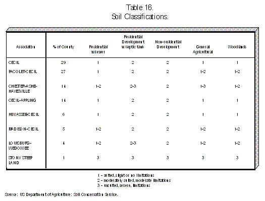
Soils The Soils Inventory (Map 4) provides a broad view of the types of soils and drainage patterns that exist in Alexander County. Soil information is important in determining land suitability for different types of land uses. Slope, wetness, depth and permeability are all characteristics used to determine soil suitability. The soil information can also indicate limitations, of varying degrees, for septic tanks, industrial development, road building and agriculture. The eight general soil associations and the general land use suitability are shown as Table 16 on the following page. As indicated by the breakdown of soil types, more than half of the land in Alexander County is considered suitable for general agriculture. Most of this land is located in the central and southern portions of the County, often coinciding with the rivers, streams and adjacent floodplains. All of the soils in Alexander County present at least moderate limitations for the use of septic tanks with drain fields. These limitations include poor percolation rates and the existence of significant rock in the soils. There are severe limitations in the northern sections of the County and in certain areas around Barrett’s Mountain. Conversely, less than 10% of the County’s land presents any limitations on central sewer system installation and operation.
All of the County’s soil inventory presents at least moderate limitations to non-residential, non-agricultural development. These limitations are attributed to rock concentrations and the potential for shrinking and swelling. Areas of the County with slopes greater than 10% are unsuitable for non-residential development. This is primarily limited to the northern third of the County. The following section provides more analysis concerning slopes and topography. Constructing roads and streets using subsoil for the base is moderately
hampered by significant rock concentrations and the lack of traffic
supporting capacity. Only in small sections of the northern part of the
County is there land completely unsuitable for road construction. |
|||||||||||
|
Topography The majority of Alexander County is located 1,000 feet above sea level. Elevations in Alexander County range from approximately 840 feet at the Catawba and South Yadkin Rivers to 2,550 feet at Walnut Knob in the Brushy Mountains, located in the northernmost section of the County. However, more than three-fourths of the land can be considered "rolling" since it is between 1,000 and 1,500 feet in elevation. Slope is expressed as the percent of vertical change per hundred feet of horizontal distance. For example, a 4% slope is one that increases or decreases four feet vertically for every hundred feet horizontally. As would be expected, the slope of the land is much steeper (up to 25% slopes) in the northern sections of the County than in other areas. The Development Constraints Map (Map 5) provides insight into areas of the County either unsuitable or limited for most development based on environmental conditions. Generally, when the slope becomes steeper, construction costs increase and environmental impacts intensify. This is due to increased grading and excavating necessary to accommodate an appropriate development site. The majority of the County is characterized by a flat or gently sloping topography of less than 8% slopes. Based only on slope and elevation, the vast amount of land in Alexander County is suitable for all types of development and all classes of road construction. Only the northernmost portion of the County in the Brushy Mountains, the
Barrett’s Mountain area and portions of the Vashti area present any
significant constraints to development. The slopes found in these areas (9%
to 25%) prevent virtually all commercial and industrial development and most
residential subdivisions. This land is suitable for individual homes, some
limited agriculture (mostly orchards) and recreational uses (hiking,
camping, fishing). |
|||||||||||
|
Hydrography and
Wetlands Hydrography concerns the presence of bodies of water, including lakes, rivers, streams, creeks, branches and ponds. Map 5 illustrates the location of these waters. The major waters in Alexander County include the Catawba, South Yadkin, Lower Little and Middle Little Rivers and Elk Shoals Creek. Several tributaries feed into these rivers. With the exception of South Yadkin River, each of the major streams flow into the Catawba River. Wetlands are areas with waterlogged soils that are often covered by water. Wetlands are a valuable resource for the environment because they act as natural filters and buffers and provide a habitat for a wide variety of fish and wildlife. While wetlands found in Alexander County do not play as large a role in the ecosystem as do wetlands along the North Carolina coast, they still remain valuable components of the County’s environment. Most of the freshwater wetlands are located as part of, or adjacent to, the identified waters listed above. Many of the County’s wetlands are found in areas located within the flood hazard areas described in the following section. Generally, field surveys are the only completely accurate manner by which the location of wetlands can be confirmed. The U.S. Army Corps of Engineers oversees the designation and regulation of wetlands. Floodplains are those areas adjacent to rivers, streams and lakes and other bodies of water that are subject to periodic flooding. Because of the higher risk for property damage, floodplains are generally unsuitable for most kinds of development. The ideal use of floodplains is for farmland, conservation or recreational areas (greenways, linear parks) to preserve the natural environment of the stream or river and to avoid inevitable property damage. As designated by the Federal Emergency Management Agency (FEMA), several "Special Flood Hazard Areas" have been identified in Alexander County. Map 5 also provides a general location of the areas that are subject to flooding by a 100-year flood event. The majority of the floodplains are located along the Catawba River, the Lower Little River, the South Yadkin River, the Middle Little River and the Elk Shoals Creeks and their tributaries. Alexander County participates in the Federal Flood Insurance Rate Mapping
program. In 1989 the County adopted a Flood Damage Prevention Ordinance
which was approved by the FEMA. This ordinance regulates development in the
designated 100-year floodplain. |
|||||||||||
|
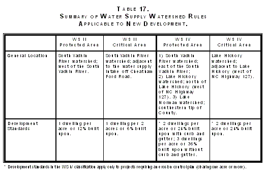
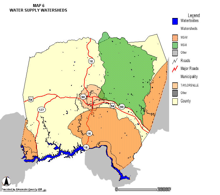
Watersheds Approximately one quarter of the County’s total land area is located within a designated water supply watershed. The North Carolina Environmental Management Commission (EMC) has designated three public water supply watersheds in Alexander County. Map 6 illustrates the location of these watersheds. The first is the South Yadkin River Watershed, located in the Yadkin River Basin in northeastern Alexander County. This watershed includes the major public water supply intake for the County’s residents. The second is the Lake Hickory Watershed, located in the Catawba River Basin in southwestern Alexander County. This watershed provides drinking water for a large portion of residents in the Unifour, including some in the Bethlehem area of Alexander County. The third is the Lake Norman Watershed, located in the extreme southeastern portion of the County. This watershed affects very few Alexander County property owners. The NC Legislature in 1989 passed legislation protecting the public water supply by regulating development in all watersheds whose surface waters provide water for public consumption. The EMC has placed all watersheds in one of five classifications (WS-I through WS-V) based on existing development. The EMC has further designated watersheds as having a critical area (one-half mile upstream from a water intake or one-half mile from the normal pool elevation of a reservoir) and a protected area (ten miles upstream from a water intake or five miles from the normal pool elevation of a reservoir).
In Alexander County, the South Yadkin River Watershed has been divided into three classifications: WS-IV (Protected Area) east of the river and WS-II (Protected Area) west of the river and WS-II (Critical Area) adjacent to the water supply intake, located on Cheatham Ford Road. The portion of the Lake Hickory Watershed in Alexander County is classified as WS-IV (Protected). The portion closest to the Lake is designated as WS-IV (Critical Area). The State Legislature has adopted statewide standards aimed at protecting
the public water supply watersheds. The purpose of these rules, which will
be effective in Alexander County on January 1, 1994, is to manage land use
and development so as to reduce the risk of contamination within the
watershed from the storm water runoff of new development. Table 17 provides
a brief summary of these regulations. |
|||||||||||
|
Protected Plants
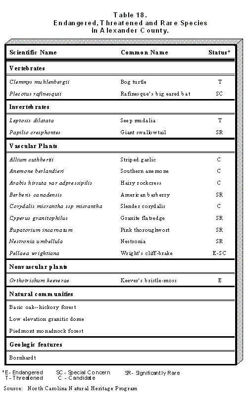
and Animal Species The Natural Heritage Program, a division of the North Carolina Department of Environment, Health and Natural Resources, maintains a working inventory of all natural elements (e.g. rare species, geological features, special animal habitats) known to occur in any given area of the State. In Alexander County, five plant and animal species are classified as endangered, threatened or species of special concern. These species are strictly protected by state law. Additionally, 13 species of plants and animals are designated as significantly rare or candidates for state protection. While these species are not protected by state law, they demand ongoing monitoring and conservation. Table 18 provides a listing of these species as well as a listing of significant natural communities and geological features. Any large-scale land disturbing activity should be reviewed by the appropriate state agencies to ensure that these protected species habitats do not exist or if they do, that they are not disturbed.
|
|||||||||||
|
Designated
Gamelands The North Carolina Wildlife Resources Commission has designated more than two million acres as North Carolina Game Lands. According to the 1993-94 Game Lands publication, the Brushy Mountains Game Land is the only state-designated Game Land in Alexander County. The Game Land is divided into two tracts totaling 2,493 acres. The first and largest tract is located in the northwest portion of
Alexander County near the intersection of State Road 1305 and State Road
1307. Hickory Knob and Walnut Knob are located within the Game Land. The
second tract is located south of NC Highway 90 in Caldwell County near the
Alexander County line. Primary game species available in the Game Land
include fox, squirrel, raccoon and deer. Camping is not permitted. |
|||||||||||
|
CHAPTER 4 COMMUNITY
FACILITIES |
|||||||||||
|
Cultural and
Historic Resources The Hiddenite Center, located in the Lucas Mansion, provides Alexander County with a prominent cultural and historic resource. The Hiddenite Center was founded in 1981 by Hiddenite natives Eileen L. Sharpe and Ruel Y. Sharpe to "preserve and perpetuate local history and culture, foster self-expression in the arts and crafts, and provide cultural and educational experiences to all within its sphere of influence." The Lucas Mansion, a Victorian home, contains a restored first-floor museum and two floors of galleries. The nearby education complex offers classes in drama, dance, lectures, special events, exhibitions, and community outreach. The Center serves the Unifour Counties as well as Wilkes and Iredell Counties. Staff includes one full-time and 12 part-time staff members as well as volunteer support. Hiddenite is also the historic home of emerald mines, prospected in the
late 19th and early 20th centuries. The largest emerald ever found in North
America, a gem of 1,440 carats, was mined in Hiddenite. The community and
its post office are named for the distinctive green mineral discovered by
William E. Hidden in Alexander County in 1880. Today visitors can spend time
digging for gems or sluicing at the site of the old emerald mine, located
just north of the Hiddenite community. |
|||||||||||
|
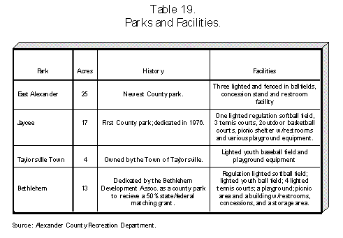
Recreation Alexander County Recreation Department currently maintains four parks within its park system: East Alexander, Jaycee, Taylorsville Town and Bethlehem Parks. Together the four parks offer active and passive recreation facilities. Active recreation facilities include ball fields for team sports, tennis courts and playgrounds; passive recreation facilities include picnic areas and walking trails. These parks are depicted on Map 7. The Alexander County Recreation Department also offers numerous sports and fitness programs using the parks and other facilities. Youth programs include football, coed soccer, girls’ softball, boys’ baseball, boys’ and girls’ basketball, cheerleading camps and open gyms. Adult programs include men’s and ladies’ softball, 16-18 basketball, men’s basketball and volleyball, coed rag ball, coed volleyball and open gyms. In addition to local recreation activities, a field trip program offering snow skiing, canoeing and rafting is provided. The Alexander County Recreation Department grew 5%-8% per year over the past five years, yet it grew 10% just last year. Plans for future growth in the park system include a proposed 79 acre park to be located at the Dusty Ridge Access area. The park will offer an adult softball field, a youth baseball field, a multi-purpose soccer-football field, picnic areas, walking trails and a boat access area. Plans have also been made for the expansion of East Alexander Park. These expansions should make the park system more accessible.
|
|||||||||||
|
Fire Protection
Alexander County currently employs no paid professional firemen. The County,
however, is served by eight volunteer fire departments: Bethlehem Community
Volunteer Fire Department (VFD), Wittenburg VFD, Stony Point VFD, Hiddenite
VFD, Vashti VFD, Taylorsville VFD, Sugar Loaf VFD and Ellendale VFD. The
locations of these fire departments are displayed on Map 7. |
|||||||||||
|
Police Protection
Alexander County Sheriffs’ Department currently has 16 officers including
four detectives, a D.A.R.E officer, ten patrol officers and the sheriff who
provide police protection for the County. Also serving the Taylorsville area
of Alexander County is the Taylorsville Town police comprised of nine
full-time officers and 11 part-time officers, seven of whom work on a
regular basis. |
|||||||||||
|
Schools
Ten
schools provide education for Alexander County students: Alexander Central
High, East and West Junior Highs and elementary schools at Bethlehem,
Ellendale, Hiddenite, Stony Point, Sugar Loaf, Taylorsville and Wittenburg.
The locations of these schools are shown on Map 7. Total enrollment for the
1990-1991 school year was 4,877 students; of which 2,714 attended elementary
school, 1,128 junior high and 1,010 high school. Seven students were
trainable mentally handicapped and 18 were exceptional students. During the
1990-1991 school year, Alexander County employed 246 teachers of whom 141
taught elementary school, 43 taught high school and 62 taught junior high
school. |
|||||||||||
|
Medical Services Located at 326 3rd Street SW in Taylorsville, Alexander Community Hospital is a full-service hospital equipped with 62 beds and nine doctors, including four family practice doctors, one general surgeon and one cardiologist; two internal medicine doctors and one pediatrician were added in July 1993. In March of 1986, the Hospital opened remodeled facilities which included hi-tech equipment, a new outpatient surgery facility, a renovated nurses station and administrative offices. In the past few years, however, the hospital has been struggling financially, losing $900,000 in the 1992 fiscal year, due in part to insufficient funds received from Medicare and Medicaid. The Alexander Community Hospital recently received a $100,000 Duke Endowment grant and $1.5 million in local bank loans. These monies are expected to be used to buy a new CAT scan machine, to pay for the nuclear medicine machine which has already been purchased and to renovate the emergency room. Alexander County provides an E-911 communications line to receive and distribute emergency calls. These calls are distributed either to the police, one of the fire departments or the EMS. Rescue services and secondary Emergency Medical Services are provided by the Alexander Rescue Squad and EMS, Inc. Two EMS stations currently operate in the County, one in Bethlehem and one in Taylorsville; each station operates one ambulance. Nine paramedics and three EMTs, working at the intermediate level, are full-time employees, while one paramedic and seven EMTs, operating at the intermediate level, work as part-time employees. In addition to the EMS, the Alexander County Rescue Squad operates with volunteer EMTs, working at the basic level. Starting in September 1993, the Alexander County EMS will operate from
the Taylorsville station, an 8:00 am -- 5:00 pm service. |
|||||||||||
|
CHAPTER 5
INFRASTRUCTURE |
|||||||||||
|
Roads and Highways Traffic counts are useful in determining commuting patterns and making future land use decisions. The NC DOT provides annual Average Daily Traffic (ADT) counts at various locations. The 1992 counts indicate that the highest traffic volumes in Alexander County -- 15,000 cars at the US 64-NC 90 intersection with NC 16 -- are in, and immediately surrounding, the Town of Taylorsville. These counts signify the presence of consistent, daily activity. In part, this traffic volume confirms Taylorsville’s role as the center and major crossroads of the County. Alexander County is primarily served by three major highway corridors. All three are two-lane, fully accessible corridors. Driveway permits are required from the North Carolina Department of Transportation (NC DOT) prior to development, but there are no other access controls. Map 8 shows these highways as well as secondary and local roads. NC Highway 16 provides an important transportation link with Wilkes County to the north and Catawba County to the south. The road provides Alexander County with one of two bridges across the Catawba River. Excluding the roads in the immediate Taylorsville area, the portion of NC 16 south of Taylorsville is the busiest road in Alexander County. Traffic counts indicate that 8,000 cars per day cross the Little River Bridge in the Millersville community. Similar traffic counts are found at various points along the highway closer to Taylorsville. However, at US 64 - NC 90 the traffic separates and much lower counts are found (3,900 cars) north of Taylorsville. A second highway, the existing US 64 - NC 90, offers the only major eastbound route to Statesville and I-77. It also provides the only easy connection with Lenoir and Caldwell County to the west. Traffic counts include 7,300 cars at Stony Point and 5,200 cars at NC 127. This road is used for local traffic more than any other road in Alexander County. Most of the County’s commercial and industrial development is along this highway east of Taylorsville. The third major corridor is NC 127 which begins south of Hickory and ends approximately five miles west of Taylorsville. This provides residents with a second option for crossing the Catawba River to the south. NC 127 is the major traffic carrier between Bethlehem and Hickory. Traffic counts of 11,800 in Bethlehem and 14,700 in Catawba County, south of the Catawba River, indicate that Bethlehem serves as a "bedroom community" for Hickory. Counts at the edges of the County -- 6,600 cars at the Iredell County line on US 64 - NC 90 and the 14,700 cars at the Catawba County line -- are relatively high, thus indicating a distinct pattern of "out-commuting," that is, residents leaving Alexander County for employment. As discussed in the County Profile section of this Plan, 1990 US Census data support this trend. Relatively few new NC DOT transportation projects are planned for Alexander County over the next seven years. One major project, however, construction of a new US 64 - NC 90 corridor just south of the existing US 64 - NC 90, is well underway with construction to be completed in early 1995 (see Map 8). The road will be approximately 18 miles long from Taylorsville to Statesville, with 11.3 miles in Alexander County. It will intersect with the existing US 64 - NC 90 Highway west of Taylorsville and connect with I-40 west of Statesville. The highway will initially be a two-lane facility. The right-of-way for an additional two lanes, however, has already been acquired by the NC DOT. These additional lanes will be added when the traffic volume necessitates the widening. Unlike the other major highways in Alexander County, this highway has been designed as a limited access facility. This designation and design prevents all property owners from constructing private driveways onto the road. Access to other state roads will be provided at 13 locations. One access point, at Highway 16, will be a cloverleaf interchange design with traffic signals. Two other points, at SR 1188 and Liledoun Road, will be normal intersections with traffic signals. The other 10 access points will be intersections with stop signs. The access controls planned for this highway will provide for smooth and efficient traffic movement into and out of Alexander County. It also presents the County with the challenge of planning for the most productive use of properties adjacent to the highway. Much of the land along this highway will be directly adjacent to the road but will essentially be landlocked unless the County provides other alternatives. Outside of the new US 64 - NC 90 highway, the latest NC DOT
Transportation Improvement Program (TIP) indicates that there are six bridge
replacements in various planning stages, including the Highway 16 bridge at
the Catawba River. There are also major road improvements planned for the
entire span of NC 16 in Alexander County, the existing US 64 - NC 90 highway
west of Taylorsville to the Caldwell County line and NC 127 from the
existing US 64 - NC 90 highway to the Catawba County line. |
|||||||||||
|
Water Water service in Alexander County is provided by three sources. The existing and proposed service areas are depicted on Map 9. These service areas indicate the existence of water mains and laterals serving the majority of property owners in a given area but do not necessarily indicate that every property owner has direct access to public water. Over time minor extensions are made to serve individual properties. The Alexander County Water Corporation, a private non-profit utility organization, provides water service to the eastern part of the County, generally along the existing US 64 - NC 90 Highway. The Water Corporation’s water treatment plant, located on Cheatham Ford Road, can process 2 million gallons per day. The Water Corporation serves approximately 2,000 customers and sells water to Alexander County as well as to the Town of Taylorsville which distributes water to its residents. Alexander County is the second provider of water service. The areas served include the Bethlehem area and along approximately three-fourths of NC Highway 16 in the County, both north and south of Taylorsville. The areas are divided into separate water districts with the County Commissioners serving as the Board of Directors in each district. The third water source, the Town of Taylorsville, provides water service to the majority of its residents. The Town owns and operates a water system but, like the County, purchases water from the Alexander Water Corporation. The City of Hickory also provides water to the Bethlehem area but does
not own any water lines in Alexander County. However, the proposed
inter-connect lines will link the water lines in Bethlehem with the rest of
the system. The inter-connect lines will be located along NC Highway 127 and
the existing US 64 - NC 90 Highway. After this connector is completed, the
County will continue to obtain water from the City of Hickory but will be in
a position to serve other areas of the County as well. |
|||||||||||
|
Sewer Unlike water service, central sewer service in Alexander County is essentially limited to the Town of Taylorsville. There is no private sewer authority nor is there a coordinated public effort underway to provide that service. Residents rely on individual septic systems and drain fields to dispose of wastewater. Non-residential establishments use septic systems of varying sizes and capacities depending upon use and treatment needs. The County is in the process of installing sewer lines from the Town of Taylorsville to the Broyhill Plant located on the existing US 64 - NC 90 Highway at SR 1421 (see Map 9). The County will own the lines and the Town of Taylorsville will treat the wastewater. Because of the relatively low treatment capacity that is available, other users along this 2.5 mile stretch will be reviewed on a case-by-case basis before being granted access to the line. Unfortunately, plans for additional sewer lines beyond this minor extension are not being considered at this time. Occurrences of failing septic tanks are becoming more frequent in Alexander County due to inadequate soils. While the problem occurs sporadically throughout the County, it is primarily concentrated in older residential subdivisions in the Bethlehem area. In these subdivisions, such as Lakemont Park, septic systems are failing with no land suitable to replace the tank and drain fields. This places individual property owners in a predicament with no easy solutions. Perhaps more importantly, large concentrations of failing septic tanks may begin to threaten groundwater quality which in turn poses potentially irreparable damage to the area’s drinking water. The lack of sewer service can also become a major economic liability in competing for new industrial and commercial development. The County is currently at a crossroads with two distinct paths concerning its future. The first choice includes a long-term commitment to provide sewer to areas with prime development potential (especially along the new US 64 - NC 90 Highway and in the Bethlehem area). With this commitment, Alexander County could place itself in a position to compete with surrounding counties in attracting new industrial development. To accomplish this choice will also require expansion to the Taylorsville sewer plant as well as an agreement with the City of Hickory. The alternate path involves no efforts to extend sewer service and
limited efforts to attract new industry. This choice will allow Alexander
County to continue developing as a bedroom community, with its residents
working and recreating in Hickory, Statesville, Lenoir and Wilkes County. |
|||||||||||
|
Other Utilities
Electric power is provided by Duke Power, Crescent Electric Membership
Cooperative and Blue Ridge Electric Membership Cooperative. Centel provides
telephone service to the Bethlehem area while Southern Bell serves the
remainder of the County. Natural gas service, through Piedmont Natural Gas,
is soon to be available in the Bethlehem area. |
|||||||||||
|
CHAPTER 6 FUTURE
LAND USE The Future Land Use Plan was developed using major elements outlined in Chapters 2-5 and the findings from public participation, including recommendations from the Steering Committee. The Future Land Use Plan is intended as a means for making sound land use decisions regarding both public and private investment as well as the preservation of natural and economic resources. To be fully effective, it should be used in conjunction with other land management tools such as zoning and subdivision regulations. The classifications, described in the following subsections and depicted on Map 10, are intended to provide a framework from which land development policies may be developed rather than as regulatory mechanisms. |
|||||||||||
|
Land Use
Classifications In accordance with the requirements of the Mountain Area Planning Program (MAPP), seven classifications are identified in the Plan. These classifications will be consistent with other MAPP Plans, thus providing the state a visionary look at the future growth and development of the 24 mountain area counties. The classifications, as described by state planners, and descriptions of those portions of Alexander County (see Map 10) are presented in the following sections. "Developed" The purpose of the Developed class is to provide for continued intensive development- and redevelopment of existing cities, towns and their urban environs. Areas meeting the intent of the Developed classification are currently urban in character where minimal undeveloped land remains and that have in place, or are scheduled for the timely provision of, the usual municipal or public services. This classification is exclusively located within the Town of Taylorsville. Taylorsville has both public water and sewer available to its residents. This is the only area in the County where both services are offered. "Urban Transition" The purpose of the Urban Transition class is to provide for future intensive urban development on lands that are suitable and that will be provided with the necessary - urban services to support intense urban development. Areas meeting the intent of the Urban Transition classification are presently being developed for urban purposes or will be developed in the next five to ten years to accommodate anticipated population and urban growth. Alexander County is experiencing spillover development from the Hickory area. The Future Land Use Plan Map represents this transitional growth in the Bethlehem area. The Map also indicates rapidly increasing development in the east-central portion of the County after the new US 64 - NC 90 Highway is completed. "Limited Transition" The purpose of the Limited Transition class is to provide for development in areas that will have some services but that are only suitable for lower densities than those associated with the Urban Transition class and/or areas that are geo- graphically remote from existing towns and municipalities. Areas meeting the in- tent of the Limited Transition classification will experience increased development (primarily residential) during the planning period. They will be in a state of development- necessitating some municipal type services such as community water or sewage systems. Generally the areas along the major corridors are designated as the Limited Transition classification. Many of these areas either have public water or will receive public water within the next 5-10 years. These areas will experience increasing residential growth as Bethlehem develops and the new corridor becomes more urbanized. Residential development from the Hickory area will account for major portions of this type of growth in the southern portion of the County. "Community" The purpose of the Community class is to provide for clustered, mixed land uses at low densities to help meet the housing, shopping and employment needs of rural areas. Areas meeting the intent of the Community classification are presently developed at low densities that are suitable for private septic tank use. Municipal type services should be anticipated only to correct existing or projected public health hazards. The southern half of Alexander County will experience more urban growth over the next several years. Conversely, the northern half will most likely continue to remain rural in nature and will demand few public services or new development. One area that may experience some clustered shopping and employment needs is Vashti. This community is indicated on the map as the only area designated as the Community classification. "Rural" The purpose of the Rural class is to provide for agriculture, forestry, mineral ex- traction and other allied land uses. Areas meeting the intent of the Rural classification are appropriate for or presently used for agriculture, forestry, mineral ex- traction and other uses that due to their hazardous or noxious nature should be located in a relatively isolated and undeveloped area. Very low density dispersed single family residential uses are also appropriate within the Rural class. This classification represents more than one-half of the County’s total land area. These areas are currently used for agriculture, forestry, low density housing, including mobile homes. There are essentially no public water or sewer services in these areas nor are there future plans for public utility expansions. The majority of this class is found in the northern half of the County. The existence of increasing slopes and the WS-II Watershed Protection Classification in the County’s northeast quadrant make urban development impractical. "Rural with Services" The purpose of the Rural with Services class is to provide for very low density land uses including residential use where limited water services are provided to avert an existing or projected health problem. Areas meeting the intent of the Rural with Services classification are appropriate for very low density residential uses and where provision of services will not disrupt the rural character of the land. The extreme southeastern portion of the County has the potential for obtaining public water service. However, due to the location of prime farmland soils, the existence of extensive floodplains and the current agriculture use, the area should be preserved as agricultural land with rural development. "Conservation" The purpose of the Conservation class is to provide for the effective long-term management and protection of significant, limited or irreplaceable areas. Management is needed due to the natural, cultural, recreational, scenic or natural productive values of both local and more than local concern. Areas meeting the intent of the Conservation classification include lands significant because of their natural role in the integrity of the mountain region such as ridge tops, areas of excessive slope, floodplains, wetlands, areas with a high potential for wildlife habitat and areas that contain significant productive, natural, scenic, cultural or recreational resources. The majority of Alexander County has a topography that could be described as rolling. However, several relatively significant peaks and ridge lines exist. These regions should be protected from industrial and residential exploitation. They represent an important part of the topographic diversity of Alexander County. They also represent a true gateway to the Blue Ridge Mountains and provide the region with prime recreational opportunities including hunting, fishing, camping and hiking. Prime areas in this category include the Brushy Mountains range (northwest Alexander County), Rocky Face Mountain (northeastern Alexander County) and Asbury Mountain (northeastern Alexander County). Barrett's Mountain was not included in this classification because of the anticipated demand for low-density residential development. The North Carolina Nature Conservancy has purchased 75 acres on Joe and
Little Joe Mountains, located east of NC Highway 16 North, near Sugar Loaf
Mountain. To preserve rare plant habitats in this area, the Conservancy
plans to add another 75 acres to this preserve in the near future. |
|||||||||||
|
CHAPTER 7 ISSUES,
GOALS AND STRATEGIES |
|||||||||||
|
ISSUE I: Protection of the County’s drinking water. GOAL: Protect the County’s water supply from (1) the negative effects of non-point source pollution and (2) the threat of groundwater contamination from failing septic systems. STRATEGIES: |
|||||||||||
| 1. |
Adopt a Water Supply Watershed Ordinance by January 1, 1994 as mandated by
the State of North Carolina for all identified public water supply
watersheds (see Map 6). |
||||||||||
|
|
Without County-wide zoning, the most practical method appears to be to adopt
a separate, stand-alone Watershed Ordinance enforced by the Planning and
Inspections Department. |
||||||||||
|
|
Encourage clustering of new development to preserve increased amounts of undisturbed, open space. | ||||||||||
|
|
Consistent with the State-mandate, the County should adopt a policy to
direct the use of the "5%/70% development option" towards areas with public
water and the potential for public sewer. |
||||||||||
|
As explained in Chapter 3: Environmental Concerns much of the
northeastern quarter of the County is affected by the WS-II Watershed
classification. This class allows extremely low density development but
provides that 5% of the watershed (outside of the Critical Area) may be
developed with non-residential- projects not to exceed 70% built upon. |
|||||||||||
| 2. | The County Health Department should prepare for the County Commissioners an annual status report on failing septic tanks with recommendations to remedy the most significant problems. Septic tank repair areas should continue to be required when permits are issued. | ||||||||||
|
ISSUE II: Expansion of public water and sewer services. GOAL: Provide adequate public water and sewer service to growing
areas and areas with environmental health concerns. |
|||||||||||
| 1. |
Accelerate plans for obtaining sewer service from the City of Hickory for
the Bethlehem area. |
||||||||||
| 2. |
Within
one year, begin planning to provide sewer service for the new US 64 - NC 90
Highway corridor. |
||||||||||
| 3. |
Ensure
that water service is extended from the new inter-connect line to the
Ellendale School located on US 64 - NC 90. Ellendale is the only school in
the County without access to public water service. The previous CDBG grant
application for this project should be resubmitted to the state for
reconsideration. |
||||||||||
| 4. |
Prepare
an on-going five year Capital Improvements program as a blueprint for future
water and sewer expenditures. |
||||||||||
| 5. |
The Alexander Economic Development Commission and the
County Board of Commissioners should vigorously pursue all possible state
and federal grants for improving water and sewer service. |
||||||||||
|
ISSUE III: Management of County’s transportation facilities. GOAL: Capture and maximize the economic potential of the transportation net work in Alexander County without overburdening the traffic carrying capacity of the roads and highways. STRATEGIES: |
|||||||||||
| 1. |
Prepare and adopt a corridor land development plan for
the new US 64 - NC 90 Highway within two years. At a minimum, this plan
should include: |
||||||||||
|
|
Access
management planning, aimed at maximizing the use and development of adjacent
properties landlocked from the highway. The highway is being constructed as
a "partial control of access facility." This design essentially eliminates
properties adjacent to the highway from obtaining access to it. All access
points will be at the 13 planned intersections. It is essential that a
coordinated plan be prepared to maximize the use of land along the highway. |
||||||||||
|
|
An inventory of land with prime industrial or commercial potential. | ||||||||||
|
|
An
inventory of prime farmland and measures to preserve irreplaceable
agricultural land, including a program for voluntary farmland preservation
as provided in G.S. 106-61. |
||||||||||
|
|
Land use management tools to preserve the economic potential of land adjacent to the highway. | ||||||||||
|
|
Measures
to preserve the visual quality of the highway by eliminating the potential
for poor site design and averting the proliferation of signs and bill-
boards. |
||||||||||
|
|
An ongoing assessment of needed improvements to nearby roads and high- ways impacted by the new highway. | ||||||||||
|
|
A proposal to determine how public sewer service will be provided to the properties adjacent to the highway. | ||||||||||
| 2. |
Request the Department of Transportation’s Statewide
Planning Group to prepare a County-wide Thoroughfare Plan. Presently the
Town of Taylorsville and the Hickory-Newton-Conover Metropolitan Planning
Organization are updating their Thoroughfare Plans. The County plan should
be coordinated with these efforts. |
||||||||||
| 3. |
Encourage commercial development at intersections through
land use management tools and selective utility expansions. Development at
intersections facilitates better site design and traffic flow. |
||||||||||
| 4. |
Develop a
long-range plan to eliminate most dirt and gravel roads. With assistance
from the Department of Transportation, identify all secondary roads in need
of these improvements. |
||||||||||
| 5. |
Explore
the potential NC DOT "Scenic Highways" designation for highways in Alexander
County, especially between Hiddenite and Vashti. |
||||||||||
|
ISSUE IV:
Promotion of economic growth and development. GOAL: Encourage increased commercial and industrial development as a means for providing new jobs, economic stability and a more balanced tax base.STRATEGIES: |
|||||||||||
| 1. |
Create "redevelopment districts" in areas such as Stony
Point and Hiddenite to encourage the preservation of existing commercial
character while promoting new development and redevelopment. By creating
districts, special problems and unique attributes can be addressed more
efficiently. To be successful, members of the individual business
communities and the Economic Development Commission should be at the
forefront of this effort. |
||||||||||
| 2. |
Continue
to identify and protect areas with prime development potential based on an
analysis of transportation facilities, property visibility, available
municipal services, soil types and topography. |
||||||||||
| 3. |
Identify
specific sites suitable for future public-private ventures, especially
industrial parks. |
||||||||||
| 4. |
Promote
and aid in the expansion of existing manufacturing establishments. |
||||||||||
| 5. |
Prepare a detailed economic forecast of the Bethlehem
area, detailing its growth potential and future shopping and employment
needs. |
||||||||||
| 6. |
Aggressively pursue State and Federal funds for water and sewer improvement
projects. |
||||||||||
|
ISSUE V: Guidance of future growth and development in areas with prime development potential through land use management techniques. GOAL: Investigate the pros and cons of all types of land use management tools aimed at encouraging organized land development. STRATEGIES: |
|||||||||||
| 1. |
Establish a County-wide task force to explore the
County’s need for land use management aimed at protecting the County’s high
growth areas from poorly planned development patterns. Future growth should
be managed by creating a balance and cohesiveness among residential,
commercial and industrial development. Special attention should be given to
future development along the US Highway 64/90 Bypass route as well as in the
Bethlehem area. Several issues that should be examined include: |
||||||||||
|
|||||||||||
|
|||||||||||
|
|||||||||||
| 2. |
Establish
a County Planning Board to provide advice and direction to the Board of
Commissioners concerning long range planning issues. Initially, the Planning
Board should review the findings of the land use management task force and
recommend appropriate policies to the Board of Commissioners. |
||||||||||
| 3. |
Pursue the rapid revision of the current County tax maps and land records,
preferably using Geographic Information System (GIS) technology. |
||||||||||
|
ISSUE VI: Preservation of the County's natural,
historic and cultural resources. |
|||||||||||
|
GOAL: Protect and maintain the County’s valuable
natural, historic and cultural resources from encroaching development or
environmental hazards. |
|||||||||||
| STRATEGIES: | |||||||||||
| 1. |
Preserve
the County’s visual quality and its rural character by encouraging new high
density development in appropriate areas and discouraging it in areas
sensitive to change such as ridge lines and farmland. |
||||||||||
| 2. |
Investigate the need for farmland preservation in areas
with potential development pressures. A Farmland Preservation Ordinance
should be considered as an appropriate means to balance development
pressures with farmland conservation. |
||||||||||
| 3. | Prepare a long-term needs assessment of recreational opportunities for the next 10 to 20 years. This assessment should include an exploration of the following: | ||||||||||
|
|||||||||||
|
|||||||||||
|
|||||||||||
|
|||||||||||
|
|||||||||||
|
|||||||||||
| 4. |
While response times from volunteer fire departments,
rescue squads, EMS and the Sheriff’s Department are presently adequate,
service areas should be carefully monitored as the County grows and demands
increase. |
||||||||||
| 5. |
Encourage
the establishment of conservation areas in close proximity to irreplaceable
natural and historic features such as the Brushy Mountains, Rocky
Face Mountain and the Hiddenite emerald mines. | ||||||||||
| 6. |
Enforce the sedimentation and soil erosion control regulations as outlined
by the NC Department of Environment, Health and Natural Resources. |
||||||||||
| 7. |
Promote
the further use of public schools for recreational, cultural and social
activities. |
||||||||||
| 8. |
Protect and preserve the endangered, threatened or rare
wildlife or vegetation species as described in Chapter 3: Environmental
Conditions. |
||||||||||
|
ISSUE VII: Provisions for safe and affordable
housing. |
|||||||||||
|
GOAL: Provide affordable housing alternatives that
incorporate safe living conditions for all County residents. |
|||||||||||
|
STRATEGIES: |
|||||||||||
| 1. |
Develop a
detailed inventory and analysis of the County’s housing stock including
manufactured housing and the conditions of the existing housing stock.
| ||||||||||
| 2. |
Continue to actively pursue State and Federal grants for
housing rehabilitation projects. |
||||||||||
| 3. |
To avoid environmental hazards, encourage the
construction of residential development in areas with adequate public
utility services or areas suitable for development with well and/or septic
tanks. |
||||||||||
| 4. |
To provide residents with affordable housing choices in
the next 10-20 years, encourage builders to provide a wide variety of
housing types, sizes and values. These types may include apartments,
townhouses and clustered residential development. Additionally, a wide range
of site-built single family development should be provided based on location
and existing development. |
||||||||||
|
ADDITIONAL MAPS |
|||||||||||
|
Map 3 |
Map 6 |
Map 8 |
|||||||||
|
|
|
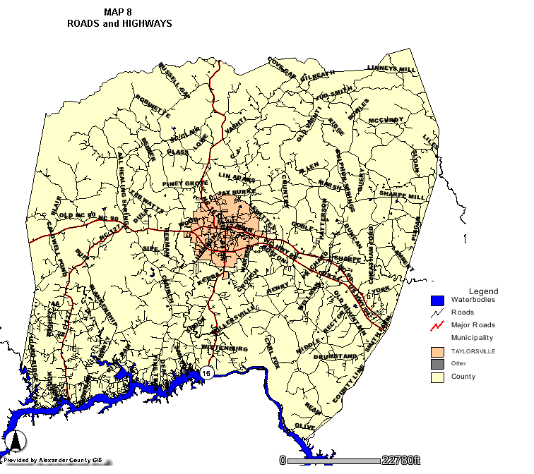 |
|
||||||||