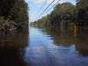
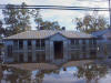

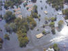
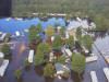
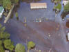
These were the headlines shortly after Hurricane Floyd struck North Carolina. Flooding in North Carolina can be devastating.
Hazard Vulnerability Assessment
Flooding:
General information index. Also see current hazard mitigation measures. Also see Alexander County and Taylorsville flood plain maps (FIRMs)
Alexander County, Hiddenite, Stony Point and Taylorsville have all experienced the effects of flooding. Fortunately there are only a handful of areas that are subject to routine, repetitive, flash flooding and in these areas there are no known residential or commercial structures at this time.
These were the headlines shortly after
Hurricane Floyd struck North Carolina. Flooding in North Carolina can be
devastating.
|
Thirty-five deaths blamed on Floyd |
|
|
RALEIGH, Sept. 20 – State officials confirm 19 deaths in eastern North Carolina in Hurricane Floyd’s wake. A total of 35 are presumed dead based on the incidents in this county-by-county list. Two others are known to be missing. |
To examine its vulnerability to flooding and make an appropriate assessment, the county and the municipality choose several sources for information. One is the HAZUS program offered by FEMA. HAZUS provides a computer model whereby certain data can be obtained based on local conditions. The flood loss estimation methodology consists of two basic analytical processes: flood hazard analysis and flood loss estimation analysis. In the hazard analysis module, characteristics such as frequency, discharge, and ground elevation are used to estimate flood depth, flood elevation, and velocity. In the loss estimation module, physical damage and economic loss is calculated based on the results of the hazard analysis. The results are displayed using a series of reports. Another method was to examine currently available FIRMs (Flood Insurance Rate Maps) also provided by FEMA. These FIRMs have been placed as a layer upon the Alexander County GIS system and were instrumental in the development of the number of structures likely to be affected. This floodplain layer was then used to input data into the damages model. The results are listed below.
| ZONE | DESCRIPTION |
| A | AREAS OF 100-YEAR FLOOD; BASE FLOOD ELEVATIONS AND FLOOD HAZARD FACTORS NOT DETERMINED. |
| AO | AREAS OF 100-YEAR SHALLOW FLOODING WHERE DEPTHS ARE BETWEEN ONE (1) AND THREE (3) FEET; AVERAGE DEPTHS OF INUNDATION ARE SHOWN, BUT NO FLOOD HAZARD FACTORS ARE DETERMINED. |
| AE | BASE FLOOD ELEVATIONS DETERMINED. |
| AH | AREAS OF 100-YEAR SHALLOW FLOODING WHERE DEPTHS ARE BETWEEN ONE (1) AND THREE (3) FEET; BASE FLOOD ELEVATIONS ARE SHOWN, BUT NO FLOOD HAZARD FACTORS ARE DETERMINED. |
| A1-A30 | AREAS OF 100-YEAR FLOOD; BASE FLOOD ELEVATIONS AND FLOOD HAZARD FACTORS DETERMINED. |
| A99 | AREAS OF 100-YEAR FLOOD TO BE PROTECTED BY FLOOD PROTECTION SYSTEM UNDER CONSTRUCTION; BASE FLOOD ELEVATIONS AND FLOOD HAZARD FACTORS NOT DETERMINED. |
| ANI | AREA NOT INCLUDED. NO FLOOD HAZARD DATA AVAILABLE. |
| B | AREAS BETWEEN LIMITS OF THE 100-YEAR FLOOD AND 500-YEAR FLOOD; OR CERTAIN AREAS SUBJECT TO 100-YEAR FLOODING WITH AVERAGE DEPTHS LESS THAN ONE (1) FOOT OR WHERE THE CONTRIBUTING DRAINAGE AREA IS LESS THAN ONE (1) SQUARE MILE; OR AREAS PROTECTED BY LEVEES FROM THE BASE FLOOD. |
| C | AREAS OF MINIMAL FLOODING. |
| D | AREAS OF UNDETERMINED, BUT POSSIBLE, FLOOD HAZARDS. |
| V | AREAS OF 100-YEAR COASTAL FLOOD WITH VELOCITY (WAVE ACTION); BASE FLOOD ELEVATIONS AND FLOOD HAZARD FACTORS NOT DETERMINED. |
| V1-V30 | AREAS OF 100-YEAR COASTAL FLOOD WITH VELOCITY (WAVE ACTION); BASE FLOOD ELEVATIONS AND FLOOD HAZARD FACTORS DETERMINED. |
| X | AREAS DETERMINED TO BE OUTSIDE 100-YEAR FLOODPLAIN. |
| X1-X30 | AREAS OF 500-YEAR FLOOD; AREAS OF 100-YEAR FLOOD WITH AVERAGE DEPTHS OF LESS THAN ONE (1) FOOT. |
For the purposes of planning, the vulnerability assessment to this hazard used Alexander County GIS and the contour layer. Using this system allowed access to a foot print of every structure currently on maps and currently located in the floodplain. To be of maximum benefit to Alexander County it was felt that listing structures by road name would be best. Emergency services may then use this information to enhance warning systems of persons in affected areas. Enhancement of that warning system, however, is not part of this analysis. There may be overlaps in population because a number of these waterways merge at various points. Also many creeks empty into or become part of the Catawba River. Catawba River levels are controlled by dams and flood gates. Therefore high water flooding in these areas is unlikely. Still, they are considered as having a potential threat from flooding. The majority (approximately 73%) of structures and population that could potentially be effected fall into this category. Digital images of the Alexander County 100 year flood plain and Taylorsville 100 year flood plain are available. FEMA Flood Insurance Rate Maps (FIRMs) are available from FEMA, Alexander County Emergency Management and the Alexander County Planning Department. New floodplain maps are expected to be produced by FEMA and North Carolina Emergency Management within the next 24 months which may enhance this assessment. Alexander County's NFIP participation number is 370398. Taylorsville does not currently participate in the NFIP, but may chose to do so in the future.
There are no known critical facilities in either the 100 or 500 year flood plain in the county or the Town of Taylorsville! The Town of Taylorsville however does experience localized flooding in three areas of concern. These areas of concern, while not within the currently mapped floodplain, are known to local officials and residents. Heavy rains for periods of 24 to 48 hours appear to cause certain drainage problems along a tributary of Muddy Creek. No loss or repetitive loss has occurred to date. These "special concern" areas are a goal of the Town to mitigate. See mitigation Implementation for the specific goal. These "special concern" areas in Taylorsville are:
|
Location |
Structures within 100' |
Critical facilities within 100' |
| Northwood Park Road, 100' either side of the center of the tributary. | 0 | 0 |
| South Center Street, 100' either side of the center of the tributary, near Hancock and Moore | 0 | 0 |
| Northmont Road, 100' either side of the tributary. | 0 | 0 |
There may be X Zones included in the estimates below. Elevation,
discharge, and flow were not
calculated and location information was extrapolated only from within the
boundary of the 100 year flood plain. The following are maximum numbers
for planning purposes and analysis only.
Structural counts listed below are approximate and based upon a manual count of structures in the floodplain using the Alexander County GIS system. It was often difficult to determine if the structure was a habitable structure or large outbuilding. Address information could not be obtained at this time. Of the structures analyzed approximately 92% were along the Catawba River below Oxford Dam. There were no habitable structures in the Town of Taylorsville listed or located on current FIRMS within the SFHA (Special Flood Hazard Area) and no indications that development had occurred. Examination of proposed development in Taylorsville gives no indication that any habitable structures are likely to be built in the SFHA in the future.
Table F1
|
Total Structures and Population in Flood Plain |
|||
| Number of residential or commercial structures: |
Population estimate: |
||
| 100 Year Flood Plain | 417 | 100 Year Flood Plain | 1,376 |
| 500 Year Flood Plain | 0 | 500 Year Flood Plain | 0 |
| Road Name | # Structures | Road Name | # Structures | Road Name | # Structures | Road Name | # Structures |
| Bakers Cove | 4 | Greene | 2 | Michaels Gap | 5 | Riverview | 4 |
| Ben Eller | 15 | Green Creek | 3 | Miller Bridge | 7 | Rink Dam | 2 |
| Bible Camp | 4 | Gregory & Michael | 1 | Miller Point | 1 | River Haven | 4 |
| Blair | 2 | Hahn Point | 3 | Moretz | 3 | River Hills | 2 |
| Bluegrass | 1 | Hammer Ridge | 9 | Morgan | 1 | River Point | 1 |
| Boot Heel | 1 | Harbor Town | 3 | Mull | 3 | River Sholes | 3 |
| Bowman | 3 | Heavenly Acres | 3 | NC16/Terrace Lawn | 9 | Rocky View | 3 |
| Bref | 3 | Hidden Valley | 1 | NC127 | 4 | Rutt | 1 |
| Charlotte Ann | 1 | Hoot Owl | 4 | Nester | 5 | South Point | 1 |
| Church | 5 | Horseshoe Bend | 6 | North Hughes | 5 | Shiloh Church | 4 |
| Clouse | 6 | Houston | 6 | North Shore | 2 | Sigmon Drum | 2 |
| Cloverdale | 1 | Hughes | 6 | Old Devil Track | 5 | Sonnys Cove | 1 |
| Crappie Hollow | 1 | Icard Bridge | 3 | Old Field | 1 | Sam Poole | 4 |
| Cove Crest | 2 | Iswa | 5 | Old NC90 | 6 | Swan | 1 |
| Coveside | 2 | Jack Shook | 1 | Old Wilkesboro | 1 | Tadpole | 4 |
| Cove View | 2 | Jennings | 1 | Olive | 1 | Three Forks Church | 2 |
| Davis Cove | 5 | Kirkpatrick | 11 | Peaceful | 1 | Timber | 3 |
| Dewey Austin | 1 | Lakeside | 10 | Pearcy Deal | 2 | T Ville Beach | 5 |
| Dexter Deal | 1 | Lakeshore | 4 | Penelope | 1 | Twins Cove | 4 |
| Dove | 3 | Lake Forest | 1 | Peninsula Island Pt | 3 | US64 | 1 |
| Dover Church | 9 | Lake Point | 5 | Perlman | 3 | Victoria | 2 |
| Drumstand | 3 | Lake Pond | 1 | Pin Oak | 1 | Walt Jolly | 3 |
| Edgewater | 2 | Lake Trail | 4 | Pine Tree | 7 | Waterfront | 4 |
| Emerald Point | 6 | Lake Vista | 13 | Pop Munday | 3 | Waterside | 2 |
| Espie Little | 12 | Laurel Wood | 1 | Popes | 3 | Wayside Church | 2 |
| Ferguson | 1 | Leeward Point | 4 | Princess | 2 | White Pint | 5 |
| Fox Den | 2 | Little Bridge | 1 | R. Z. Bowman | 3 | Whitson Hill | 1 |
| Fred Jolly | 5 | Loudonya | 5 | Rabbit Hollow | 1 | Whren | 4 |
| Gilbert Place | 1 | Marina | 4 | Rebb | 2 | Wildlife Club | 7 |
| Glove Mill | 2 | Mariners Point | 6 | Reitzel | 1 | William Reese | 3 |
| Grasshopper | 2 | McAlpin | 1 | Ridgewood | 1 | Williams Cove | 2 |
| Windy Hills | 2 |
Table F2
* Damage estimates that may result from a catastrophic 100 year flood event:
| Structural Damage | $37,530,000 |
| Non - structural (i.e. vehicles, boats, etc.) | $2,900,000 |
| Contents | $550,000 |
| Lost inventory | Not calculated |
| Relocation losses (cost of relocating population) | $24,000,000 |
| Capital losses | Not calculated |
| Wages lost | $2,500,000 |
| Retail income losses | Not calculated |
| Total Potential Losses | $67,480,000 |
* Source - HAZUS - Mathematical calculation based on 100% of all property effected (25% structural, 25% contents) N/A indicates the data was not available or not calculated.